Click thumbnail for full size map. Maps are saved in PDF format.
|
 Nelson Lake Nelson Lake
Species: Largemouth Bass
Structure: This lake has it all. There
are plenty of rocks to fish throughout the lake, as well
as cattails and reeds. This lake also provides creeks,
flats, and strong current conditions located in the North
West end of the lake from the power plant outlet.
|

Lake Tschida
(Heart Butte
Reservoir)
Species: Smallmouth and Largemouth Bass
Structure: This lake is full of Smallmouth bass
just waiting to be caught. This lake has a ton of big
rock structure, reeds, trees and some moss. This lake is
also has been reported to produce big largemouth
bass.
|

Sheep Creek Dam
Species: Largemouth and Smallmouth Bass.
Structure: This lake has rock, reeds,
trees, and moss. Top water, and jigs seem to work best in
this lake. |

New Johns
Species: Largemouth and Smallmouth Bass.
Structure: Special chain of lakes all connected together. Multiple canals and bridges. This lake is full of reeds,
gravel, rock, islands and canals. This will probably be a
record breaking tournament.
  
|

Lake Audubon
Cabin Sites Map
Species: Smallmouth
Structure: Lake Audubon, a 16,000-acre reservoir in McLean County, North Dakota, features a diverse structure with a maximum depth of 67 feet and an average depth of 25 feet, including points, submerged channels, and islands with rocky shorelines and drop-offs.
Bring your GPS or
a map. The green line located on this map is an
indication where boats are not allowed to go during the
open months. Don’t worry this lake is 16,611 acres
big, there will be plenty of open water to fish.

North Audubon
Species: Smallmouth
Structure: Seperated by a highway from the main lake, this is a smaller version of the lake, with lots of small islands, rocks, bays. Fishes like a smaller Audubon Lake.
|

Fish
Creek Dam
Species: Largemouth
and Smallmouth
Structure: Fish Creek Dam, a 52-acre reservoir in Morton County, North Dakota, features a maximum depth of 49 feet and an average depth of 18 feet, with a structure that includes points, rockyshorelines, weed edges, and submerged cover.
|

Raleigh Reservoir
Species: Largemouth
Structure: Raleigh Reservoir, a 59-acre lake in Grant County, North Dakota, features a maximum depth of 34 feet and an average depth of 13 feet, with underwater structures like points, weed beds, and drop-offs. Its 4.3 miles of shoreline and features such as submerged cover. A significant winterkill in 2022-23 has impacted largemouth populations.
|
 Indian Creek Dam Indian Creek Dam
Species: Largemouth
and Smallmouth
Structure:The lake is full of reeds, and grass, there are some shorelines that have some rock on it but not much. There are three rip rap points on it when they landscape the lake five years ago. The dam of the lake has a rock on it as well. The shorelines average about 4-8 ft of water. It's prime for flippin and pitchin & top water.
|

Sweetbriar Dam
Species: Largemouth Bass
Structure: Sweetbriar Dam, a 252-acre reservoir in Morton County, North Dakota, features a compact structure with a maximum depth of 31 feet and an average depth of 10 feet, including points, weed edges, and submerged cover. Its 10.5 miles of shoreline and varied underwater features, such as drop-offs and docks, create productive fishing spots, especially near the two boat ramps and floating fishing piers
|

Spiritwood Lake
Species: Smallmouth
Structure: Basin with a maximum depth of about 56 feet and an average depth of 31 feet, characterized by steep breaks and varied underwater topography
|
 Lake Sakakawea Lake Sakakawea
Species: Everything, including a healthy smallmouth population
Structure: Lake Sakakawea, a massive 368,000-acre reservoir in North Dakota, features a complex structure with a maximum depth of 180 feet and an average depth of 45 feet, including deep river channels, points, bays, and submerged timber that attract smallmouth and largemouth bass. Its extensive 1,320 miles of shoreline, along with weed beds and rocky drop-offs, provide diverse habitats for bass fishing, particularly in shallower bays during summer and deeper structures in cooler seasons.
|

Isabel Lake, SD
Species: Largemouth
Structure: Isabel Lake, a 114-acre lake in Dewey County, South Dakota, features a maximum depth of 11.8 feet and an average depth of 8 feet, with lots of reeds and structures like weed beds and shallow flats
|

Pudwell Dam, SD
Species: Largemouth
Structure: Pudwell Dam’s 208-acre reservoir in Corson County, South Dakota, with its maximum depth of 25 feet and average depth of 10 feet, offers a solid structure for bass fishing, featuring weed beds, points, and drop-offs. Winterkilled in 2020 |

Lake Ashtabula
Species:Smallmouth
Structure:Lake Ashtabula, a 5,174-acre reservoir in Barnes County, North Dakota, features a long, narrow structure with a meandering drowned river channel, points, flats, rocky breaks, and weed edges that attract smallmouth bass, walleye, and other gamefish. With a maximum depth of 45 feet and an average depth of 13 feet, its varied underwater topography, including channel edges and submerged structures, provides prime fishing spots, especially near bridges and rocky shorelines. |

Lake Darling
Species: Smallmouth
Structure: Lake Darling, a 9,502-acre reservoir in North Dakota, features a diverse structure with points, flats, ledges, and weed edges that provide ideal ambush and feeding grounds for largemouth and smallmouth bass. Its maximum depth of 26 feet and submerged features like old river channels and timber attract bass, making it a prime fishery for anglers targeting these species. |

Wood Lake
Species:Largemouth
Species: Wood Lake, a 102-acre natural lake in Benson County, North Dakota, features a maximum depth of 27 feet and an average depth of 13 feet, with underwater structures like weed beds and rocky areas. Significant die-off in summer 2022. Still a fair number of decent largemouth bass, but down from several years ago
|
|
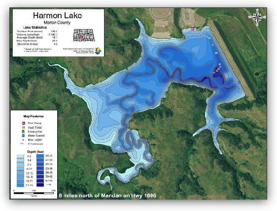
Harmon Lake
Species: Largemouth
Structure: Harmon Lake, a 136-acre reservoir in Morton County, North Dakota, features a maximum depth of 46.8 feet and an average depth of 15 feet, with underwater structures like trees, points, weed beds, and drop-offs with many creek arms.
|
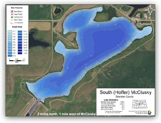
South Hoffer Lake
Species: Smallmouth
Species: South Hoffer Lake, a 125-acre lake in Sheridan County, North Dakota, features a maximum depth of 10 feet and an average depth of 8 feet, with a structure that includes weed beds and shallow flats with a portion of the McClusky canal.
l |